What it is?
First you need to define the concept. Groundwater is the upper layer of water from the surface of the earth.
Their level is high if they lie at a depth of up to two meters from the ground surface. This is not difficult to determine.
It is enough to drill a well a couple of meters deep with a hand-held garden drill in several places on the site and wait a day or two. If the level is high, the well will inevitably fill with water.
This needs to be done in the spring, since it is then that groundwater is closest to the surface due to intense snow melting.
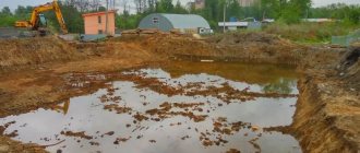
If the drilled well is dry, then there are no problems , you can calmly lay the foundation for the house or lay communications. If water is visible, it is better to wait a while and first artificially reduce its level by installing drainage.
Drilling method
Exploration drilling
One of the modern and simple ways to determine the level of perched water is carried out using a conventional hand drill. The fact is that if the layer is deeper than 2 meters, then there is nothing to worry about and you can safely carry out construction. And a garden drilling machine can penetrate such a distance perfectly. To work you will need:
- spoon drill;
- metal or other flat rod;
- roulette.
Difference from perched water
Verkhovodka is a local accumulation of groundwater located above the groundwater level. This is due to the seasonal factor and is temporary. This is precisely what makes it different.
During certain periods (for example, heavy rains or heavy snowmelt), this phenomenon is noticeable and noticeable, and during the dry period, it almost completely disappears.
The groundwater level is also subject to slight fluctuations, but not so significant, and this layer cannot completely disappear.
There is no high water on slopes and sandy areas, because in these cases there are opportunities for its natural removal.
Definition
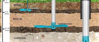
Depending on the intensity of precipitation, the geological characteristics of the area, the time of year, the proximity of natural bodies of water and a large list of reasons, wet soil may appear at different depths when digging a well. This definition includes the first stable aquifer. It is located above the clay in the sand area. The main source of replenishment of this resource is rain, snow melting, and flowing streams from mountain peaks. It is worth separating two main problems - the ability of the soil to heave, which greatly affects the characteristics of the foundations of the building, and another important factor - the size of the well and its productivity.
What can you do to dry it out?
Since this phenomenon is not uncommon, there are several proven options for artificially lowering the water level.
All of them are associated with a significant amount of excavation work, so it is more advisable to carry them out before laying the foundation for the house at the beginning of construction.
The following methods are distinguished:
- A reservoir or pond for storing excess moisture.
- Open drainage.
- Closed drainage system.
- Construction industrial dewatering using wellpoints.
How to find out how deep the water is
In addition, there is a more technologically advanced method for determining the level yourself. To do this you will need the following tools:
- Garden type drill, more than 2 meters long;
- Long metal rod.
In order to determine the depth of water using these tools, you must first drill a hole using a drill. Afterwards, leave this hole for 24 hours. Then you need to wait until the moisture collects. Next, a rod is lowered, marked with length parameter marks (similar to a ruler).
It is worth considering one of the possible options when using this method:
- A hole of 2 meters is dug;
- If the rod becomes wet at around 30 centimeters, this means that the water level is (2-0.3) = 1.7 meters, or 170 centimeters.
In this way, the depth of the water can be determined. This will help you understand how well, efficiently and simply construction work will be carried out on the site. It is important to select the appropriate type of foundation, as well as think through other issues related to construction.
How to correctly calculate the drainage of a site according to SNiP?
When constructing and calculating drainage on your site, it is recommended to follow the requirements of the relevant regulatory documents.
In relation to the topic of the article, you need to pay attention to SNiP (an abbreviation for Building Norms and Rules) 2.06.15-85 “Engineering protection of the territory from flooding and flooding”, as well as SP 250.1325800.2016 “Buildings and structures. Protection from groundwater."
SNiP clearly defines all stages of drainage creation:
- Project in which system data should be specified:
- general scheme.
- geometric data: trench parameters, their slope, distance between system elements.
- diameters of pipes used, parameters of wells.
- fasteners, materials for filling drainage trenches and pipes.
- Cleaning the area where drainage will be laid.
- Digging trenches taking into account how much the soil freezes in a particular area.
- Strengthening walls with gravel or polymer materials
- Laying of pipes, if used, taking into account the permissible material, as well as the laying depth in accordance with SNiP.
- Digging drainage wells or septic tanks, calculating the permissible angle relative to ditches or closed drainages.
Types, types and characteristics of groundwater
The main feature of such sources is their occurrence above an impermeable layer. They are divided into:
- Plast. Formed in sandstones and other permeable soils.
- Cracked. So named because the liquid fills the natural results of the destruction of solid layers that are not prone to dissolution.
- Porous. Creates an extensive network of small containers in a monolith subject to leaching (limestones, dolomites, chalk).
From this it is clear that the most abundant layers can be found in areas with large masses of sedimentary rocks located above impermeable clay or rock fields. Geology is usually very nonlinear, and underground there are both entire “lakes” formed by underlying soils and stable areas with constant movement of fluid (slopes). Due to this, the efficiency of drilling wells can vary greatly at a short distance from each other.
SGround.ru
How does groundwater affect foundations?
Table of contents
- Introduction
- The influence of groundwater on the properties of foundation soils
- Aggressiveness of groundwater
- Aquifers and perched water
- Ground water level
- Maximum forecast (calculated) groundwater level
- Capillary rise of groundwater
- Artificially lowering groundwater levels
- Conclusion
- Related Articles
Introduction
As already noted in other articles concerning frost heaving of soils, the proximity of the groundwater level to the freezing front has a decisive influence on the heaving processes. But groundwater is dangerous not only for this - in the warm season, soaking also causes a sharp decrease in the physical and mechanical properties of soil compared to a dry or moderately wet state. And for the structures themselves, groundwater is not the best neighbor, let’s figure out why.
The influence of groundwater on the properties of foundation soils
All cohesive dispersed soils (loams, clays, sandy loams) deteriorate their physical and mechanical characteristics with increasing humidity. At low humidity, clay soils are in a solid state. With an increase in the moisture content of clayey soils, they pass into a plastic state, the specific adhesion c and the angle of internal friction φ naturally decrease due to the weakening of structural bonds and the lubricating effect of water at the contacts of particles. With a further increase in humidity, it usually reaches the moisture content at the yield boundary and the soil liquefies, acquiring the properties of a viscous liquid.
[Clay soils, with increasing humidity, greatly reduce their strength qualities until they turn into a liquid state]
Photo: Under the influence of moisture, the soil has lost its bearing capacity
. Non-cohesive dispersed soils (sands, gravelly soils) are less affected by moisture, because There is practically no specific adhesion in them, and friction between particles is largely determined by the shape and nature of their surface. However, the presence of water in such soils still reduces internal friction φ - up to 20%.
[Sands and coarse soils are less susceptible to the influence of moisture, however, groundwater also has a negative effect on them, reducing internal friction by up to 20%]
The solid component of soils may also contain water-soluble minerals: gypsum, calcite, rock salt, etc., as well as organic substances that dissolve under the influence of groundwater, weakening structural bonds or forming voids.
In addition, there are specific soils for which contact with water is contraindicated - these are subsidence and swelling soils.
Subsidence soils have large pores (macropores) and low humidity and, in a dry state, are not much different from ordinary clay soils. But after soaking, they quickly become soaked, losing their structural bonds and, under load, sharply shrink due to the collapse of the pores - they sag. Sometimes the total subsidence of the foundation can be very large, up to a meter or more.
Swelling soils are clayey soils with a high content of hydrophilic clay minerals and low moisture content in their natural state. Moisture entering swelling soils is absorbed by the surface of clay particles, forming hydrate shells. When the particles are initially relatively close together, under the influence of hydration shells they move apart, causing an increase in the volume of the soil and a rise in the surface (almost like heaving).
Aggressiveness of groundwater
Most groundwater is an aggressive environment for steel structures, that is, structures immersed in it will be destroyed in a relatively short period of time: from 1 to 10 years or even faster.
Also, with a certain chemical composition, groundwater has a destructive effect on concrete and reinforced concrete structures. Groundwater that can destroy cement concrete and mortars is called aggressive. Their aggressiveness depends on the chemical composition of the salts and acids dissolved in them. These substances enter the water from underground natural deposits or from industrial waste. Therefore, aggressive waters are found everywhere.
Photo: Destruction of reinforced concrete structures under the influence of an aggressive environment
The aggressiveness of groundwater in relation to concrete is assessed by the content of: bicarbonate alkalinity, pH, the content of free carbon dioxide CO2, the content of magnesium salts (in terms of Mg ions), the content of caustic alkalis (in terms of K and Na ions), the content of sulfates (in terms of in terms of SO4 ions), the content of caustic alkalis (chlorides, sulfates, nitrates). All these indicators are determined in the laboratory during geotechnical surveys.
Water, even with a small amount of harmful substances, can be dangerous for concrete, since due to the continuous movement of water in the soil, more and more particles of harmful impurities act on the concrete. Therefore, during engineering-geological surveys, a chemical analysis of water should always be performed.
All water contains, at least in an insignificant amount, carbon dioxide (CO2). It can be bound (inactive, unable to enter into any new connections) and free (active). Bound carbon dioxide is harmless to concrete. Free (called aggressive) carbon dioxide reacts with the lime of concrete and forms water-soluble salts.
In heavily polluted water, in the presence of free carbon dioxide (CO2), and sulfates (S04), and chlorides (Cl), and magnesium oxide (MgO), soluble salts are formed by interaction with concrete, and therefore the aggressiveness of the water depends on the combination all these impurities.
In relatively clean water in the absence of chlorine (Cl) and free carbon dioxide (CO2), in the presence of magnesium salts (MgO) and sodium (NaO) in quantities less than 60 mg/l, gypsum solutions are harmful, since they lead to the formation of complex salts (“cement bacillus”), which increase in volume and therefore destroy concrete. Impurities of nitric and nitrous acids and ammonia are very harmful. On the contrary, silicic acid in any quantity is harmless.
According to the degree of impact on structures, waters are divided into: non-aggressive, slightly aggressive, moderately aggressive and highly aggressive (SP 28.13330.2012 Protection of building structures from corrosion).
The aggressiveness of groundwater depends not only on the concentration of harmful substances, but also on the soil filtration coefficient (the speed at which water passes through the soil).
[The aggressive impact of groundwater depends on the ability of the surrounding soil to pass water (filter) - the faster the soil passes water, the more aggressive it will affect structures]
To increase the resistance of concrete to the aggressive effects of a liquid environment, it is used; sulfate-resistant cements; denser concrete with water resistance grades W6, W8, W10 and more; waterproofing of structural surfaces; water reduction (drainage) (see sections 5.3, 9.3 and tables of appendices SP 28.13330.2012).
Aquifers and perched water
Often there are several aquifers underground: 2, 3 or more.
Water is retained when seeping from the surface over waterproof (mainly heavy clay) soils and accumulates in permeable (coarse, sandy) layers, which in this case are called aquifers. If an aquifer is under an aquifer, then the water in the lower aquifer is often under pressure from the overlying layers. If a pit is dug in the upper layer, water will enter it from below under pressure and rise above the level at which it originally appeared.
Such waters are called pressure waters, and the level to which they rise is called the established groundwater level. This level should be identified during engineering-geological surveys and taken into account during design.
Verkhodka is a local area of water-saturated soil limited in area, located above a waterproof lens (clays, frozen soils). As a rule, perched water has a small area and thickness, lies close to the surface, above the groundwater level. The water level in the perched waters strongly responds to the influx of atmospheric waters.
Ground water level
[Groundwater level (GWL) is the depth relative to the surface of the earth or the elevation of the free surface of the water in a well or pit. Assume a steady-state level that has not changed for at least 30 minutes]
The most accurate way to determine the groundwater level is to drill wells or dig a pit (small pit) until a free water surface (“mirror”) appears and further deepen it to 0.5-1.5 meters.
The groundwater level is not a horizontal surface and usually changes along with the relief, repeating it in a smoothed form - when the relief rises, the groundwater level also rises, but to a lesser extent.
If there are open reservoirs in the area, the groundwater level near the reservoir coincides with the mark of the daytime surface of open water and changes with it, and when moving away from the reservoir it differs up or down.
During the year, the GW also does not stand still and is constantly changing. The highest groundwater levels in latitudes with significant snow accumulation in winter are due to the infiltration of meltwater in the spring. The second, less pronounced high level is confined to the autumn rainy period. The lowest levels are observed in summer and late winter.
After the winter minimum, a sharp rise in groundwater level occurs as the snow melts. The duration of the spring maximum often does not exceed 10 days
Changes in topography during construction and soil leveling can disrupt the natural processes of redistribution and movement of groundwater, and, consequently, change the groundwater level. The main man-made disturbances are:
- Violation of the surface flow of atmospheric water - streams flowed for many years in one place, and then during construction everything was dug up, the site was raised and as a result the neighboring site began to drown in water. This phenomenon occurs quite often.
- Screening the ground surface over a large area. After this, moisture will accumulate under the closed area and the moisture content of the foundation soil will increase.
Groundwater is in constant motion, although this movement is slow and not noticeable to the human eye, it continuously occurs both vertically and horizontally towards areas of discharge (reservoirs, lowlands, rivers, etc.).
Maximum forecast (calculated) groundwater level
As calculated groundwater horizons, their highest levels should be taken in spring and autumn, and, if data are available, at the end of winter
If there is a need to obtain the calculated groundwater level, then you should use the regulatory literature. For example, “manual for SNiP 2.05.02-85 on the design of methods for regulating the water-thermal regime of the upper part of the roadbed” section 3.
The calculations are cumbersome and I will not present them here. Let me just note that when performing engineering-geological surveys, the reports usually indicate the possibility of changing the groundwater level by +/- 1.0 m from the position obtained during the survey. Less often, fluctuations take +/- 0.5 or +/- 1.5 m.
[Thus, as a rule, the calculated groundwater level should be taken as a level 1.0 meters higher than that obtained by measurements during surveys.]
Capillary rise of groundwater
[Not only soils below the groundwater level are water-saturated, but also some thickness of soils above it - this is a layer of capillary rise of groundwater]
The thickness of the layer of capillary rise of water is taken to be the distance from the level of underground water with a free surface (in the well) to the point where the moisture content of the clay soil does not exceed the moisture content at the rolling boundary.
[Humidity at the rolling boundary WP - corresponds to the humidity at which the soil loses its plasticity and turns into a solid state. The rolling out limit qualitatively corresponds to the state in which a rope rolled out from the soil to a diameter of 3 mm begins to crumble into pieces up to 1 cm long.]
The thickness of the layer of capillary rise is called the frost-risk “edge” above the groundwater level. This border depends on the composition and composition of the soil under natural conditions, and its thickness ranges from 0.3 to 3.5 m, depending on the degree of dispersion of the soil.
The capillary rise of water in soils occurs under the influence of the surface energy of mineral particles of the soil and, therefore, depends on their specific surface area. For example, in round and medium-sized sands, the specific surface area of the particles is relatively small, so in these sands there is almost no capillary rise of water and, as a result, there are no frost heave deformations (they are non-heaving soils).
Fine and silty sands consist of smaller particles compared to coarse sand, and due to the interaction of the specific surface of mineral particles with water, capillary rise in natural conditions is observed to a height of 0.3 to 0.5 m. In sandy loams, the height of capillary rise reaches from 0 .5 to 1 m, in loams - up to 1.5 m, in clays - up to 3 m.
The speed of water movement through the capillaries is much less than the rate of rise of the groundwater level and usually the capillary fringe lags behind changes in groundwater level.
Not all groundwater is of natural origin. When a water pipeline breaks, locally saturated soils swell unevenly as they freeze, causing serious damage to buildings and structures.
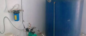
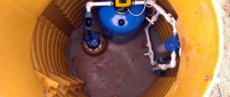
Artificial reduction of groundwater levels (drainage, dewatering)
For many summer residents and owners of private houses with a basement, the issue of reducing groundwater level is a very pressing one. How can high groundwater levels be dealt with? – it is necessary to do drainage.
There are different types of drainage: a horizontal system of drainage pipes, vertical drainage with wells or wellpoints, open drainage with channels and trays, and even the creation of artificial reservoirs. The outflow of water can be natural or forced - using pumps.
[Drainage in construction – translated into Russian means removal/discharge of water. Sometimes drainage refers to the removal of water from the surface, but more often it refers to the removal of groundwater. Can also be replaced by the term “water reduction”]
The main thing when creating drainage (water reduction) is to have somewhere to drain the water - you need a place where you can direct water from the drained area for a long time, without harming either the neighbors and their buildings, or the environment.
The flow of drainage water can be directed: to a drainage ditch outside the boundary of the site (if there is one), to the nearest body of water (if it does not have fishery significance), to a storm sewer (if there is one), in the direction of lower relief (if there is one, and if there is one) no neighbors).
In general, in most cases, drainage is feasible. This is a big topic that requires a separate discussion, so we will move it into a separate article.
Conclusion
Clay soils, with increasing humidity, reduce their strength qualities until they turn into a liquid state. Sands and coarse soils are less susceptible to the influence of humidity, however, groundwater also has a negative effect on them.
During the year, the GW does not stand still and is constantly changing. The highest groundwater levels are most often observed in spring and less often in autumn. The lowest levels are observed in summer and late winter.
As a rule, the calculated groundwater level should be taken as a level 1.0 meters higher than that obtained by measurements during surveys. But not only soils below the groundwater level are water-saturated, but also a certain thickness of soils above it - this is a layer of capillary rise of groundwater that can have a thickness of up to 3.5 m, depending on the type of soil.
Most groundwater is an aggressive environment for steel structures, and quite often groundwater has a destructive effect on concrete and reinforced concrete structures.
Conclusion - high-lying groundwater negatively affects the characteristics of most foundation soils and often has an aggressive effect on the foundation structures themselves, and they make construction work very difficult, so they cannot be called a welcome guest. During design and construction, this circumstance should be given due attention; perhaps you should provide for drainage at the foundation design stage.
Related Articles
Site drainage, drainage systems, water reduction
Open drainage system equipment
An open drainage system is the best solution if you are looking for a way to get rid of groundwater. With its help, it will be possible to drain melt and rain water where it accumulates. An open drainage system is divided into two types: point and linear. In the first case, the system is installed under drains, watering taps, and also where it is necessary to quickly remove accumulated liquid. Drainage systems of the second type are made in the form of channels with a container for collecting moisture. Many homeowners combine these two types of drainage.
To equip an open drainage system, you will need:
- concrete, crushed stone or PVC to make channels;
- protective and decorative grilles;
- storm water inlets with holes for drainage of liquid. These tanks are used for point drainage; they are located under drainpipes. Storm water inlets are made of polypropylene or polymer concrete;
- storm flaps. Necessary to prevent water from returning from the container to the pipe if it rains.
Algorithm of actions:
- We will install ditches around the perimeter of the house, the depth of which is 50–60 cm and the width of 0.5 m.
- We place rainwater inlets under the gutters. It is important that the ditches are dug with a slope of 5-10 degrees to allow water to drain better. Their shape should be V-shaped or U-shaped.
- Crushed stone or polypropylene, polymer concrete or PVC channels are laid in the trenches.
- We bring the trenches to a water collection tank, a ditch or an artificial reservoir.
We hide the channels under a grate made of cast iron. Its weight and thickness depend on the load experienced.
Where are they used?
This resource is widely used to meet household needs. In each settlement, a shallow mine is dug near the house to use water in the kitchen and for watering plants. Due to strong differences in taste, housewives prefer to take moisture for cooking from certain points. That is, the chemical composition can be different even on the same street.
In industrial quantities, use is limited due to seasonal level changes and low power. In most cases, the amount of dissolved impurities does not meet the standards. In addition, overly active exploitation can disrupt the natural water balance, and thereby affect the nature of vegetation in the area, since part of the flora receives nutrition from great depths.