A diagram of the situational plan with reference to the area is ordered along with a copy to provide information about the site in the event of its sale, as well as for connecting electrical and gas networks.
For a plot of up to 15 acres
Price from: 12,000 rub.
The price is valid until January 18
Call me back Calculate cost
What is a situation plan for the location of an object?
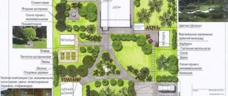
The designation on a map of the area of a land plot with highlighted boundaries, buildings located on it, communications, and adjacent neighboring territory is called a “situational plan.” According to the rules, all construction projects on it are accompanied by information about the date of construction, number of storeys, street names, and house numbering are indicated.
Wikipedia states that a situational plan is a contour plan that does not contain information about the terrain of the territory. In other words, it uses horizontal surveying to create it, as opposed to a topographic geobase, which includes displaying elevations. In addition, the application of various objects is carried out using conventional signs that are understandable to users without an engineering education.
Ready turnkey situation plan
Order
APPLICATION AREA
The creation of situational plans of areas with a designated exploration area and a mapped gas transportation system is intended for design, survey and construction organizations of the oil and gas complex and other interested organizations with the aim of:
- Conducting engineering and geodetic surveys of new construction sites.
- Ensuring the safe operation of enterprises, buildings and structures, pipeline transport and field operation;
- Carrying out reconstruction, overhaul and restoration of facilities, including buildings, structures and facilities of the oil and gas transportation system.
When is it necessary?
To conduct a transaction of purchase/sale or lease of a property from the legal side, the situation plan is not a mandatory document.
Its presence is necessary to provide complete information about the boundaries of the site, the adjacent territory, nearby favorable and unfavorable areas, security zones, etc.
You will also need to order a situation plan in the following cases:
- obtaining permission to design and build a new facility;
- carrying out reconstruction of historical buildings, monuments;
- gasification, electrification of the site.
ADVANTAGES OF GEO INNOTER LLC:
- Extensive experience in creating situational plans for areas with a designated exploration area.
- Highly qualified employees in working with remote sensing materials.
- The latest software for processing satellite images.
- GEO INNOTER LLC is included in the list of expert companies of the Ministry of Justice of the Russian Federation for analyzing remote sensing materials and conducting examinations.
To order the creation of situational plans for areas with a designated exploration area, contact us by phone, or send a request by e-mail: [email protected]
Situation plan by cadastral number online
After cadastral numbers began to be assigned to all real estate objects in 2007, transactions with them are only possible if this identifier is available. The number is issued once and is assigned to the site, regardless of the change of owner.
All information is stored in the Rosreestr database and is freely available to users, which, in turn, makes it possible to obtain a situational plan of a land plot using the cadastral number.
The package of documents for issuing a site situation plan at the MFC branch includes:
- application on a standard form;
- real estate documents confirming ownership, or an extract from the Unified State Register of Real Estate;
- identification documents.
Public cadastral map of Russia on
Therefore, there are 4 possible reasons why the site is not on the map:
- no surveying was done at all
- surveying was done a long time ago (before 2006)
- surveying was done recently (1-2 months ago)
- technical errors when registering a boundary plan
Read more in our article. The map shows only areas for which land surveying has been done (that is, the exact coordinates of the corners have been measured).
no land surveying was done at all.
Share a link to the map (read more...)
On the public cadastral map you can find any land plot or capital construction project that has been cadastrally registered in the Unified State Register of Real Estate and for which a land surveying procedure has been carried out.
Plan for gasification
When agreeing with the operational services for connecting the site to the gas network, a mandatory package of documents is drawn up, which includes a situation plan with reference to local coordinates, drawn up on an A4 sheet. Information on the possibility of preparing a situational plan for gasification is provided by the local municipality.
To obtain a situational plan of a land plot by address, it is enough to indicate the exact coordinates of the location of the object.
In the absence of such information, it is necessary to contact a specialized organization that will produce a situational plan of the land plot on a scale of 1:2000 after performing a topographic survey for gas.
It is also possible to prepare the document yourself. The basis is taken from high-resolution maps from open sources. Before this, it is necessary to notify the operational services in advance about independently drawing up a situational plan for the land plot for gasification.
What is it for?
Very often, articles try to indicate as many options as possible of why and where a situational plan is needed. Although in fact this document is needed by a fairly narrow circle of Customers, mainly legal entities. And many ignorant people, relying on unreliable sources on the Internet or among friends, order sitplans without really understanding what to do with this beautiful piece of paper. This is akin to the common misconception that a technical passport is needed for a private residential house.
We will try to dispel several of the most common misconceptions regarding the need to order a situational plan.
- It is needed to conclude real estate transactions. This is the last document you may need. It has no legal force. The only thing that will help you to navigate the area and indicate the location of the site or building. But this can be done in other ways. For the transaction, a fresh extract from the Unified State Register and a certificate are much more important (not necessary, but if available, it will add “weight” to your documents).
- It is needed for landscaping and landscaping of the land. In its most primitive form (made independently or by landscape organizations without the involvement of surveyors), it can only serve as an indicative concept for landscaping as a whole. Landscape designers often try to make a project based on their sit plan in order to “cheap” the work. However, for a serious and correct project, a large-scale topographic plan is needed.
- It is needed to register a plot of land. Also wrong. Very often they confuse the situational plan and the layout of the land plot. To register a plot of land from municipal or state property, the above-mentioned scheme is necessary.
Still, where is a situational plan useful?
- When developing design and estimate documentation at the stage of preparation for construction or restoration work. That is, at the initial design stage to order a geo-base (topographic plan). Whether it’s installing a fence near the road or assessing the possibility of carrying out reconstruction work, the site plan is designed to help preliminary “outline” the scope of work. That is, this is practically the first document before the start of a construction project.
- For coordination with Rosnedra. Although it is called a topoplan, it is essentially a situation plan indicating the coordinates of an object. You can call it a "hybrid".
- To obtain technical conditions for carrying out work on connecting to central networks. Again, to draw up a competent technical specification, the Contractor must familiarize himself with the situational plan of the territory. That is, to connect gas, electricity, water supply (for example to Mosvodokanal) , etc. But this is not the only plan you will need. Most likely, you need to order a topographic plan M 1:500 at the same time.
- Sometimes a situational plan is understood as an inventory plan. Typically, large industrial or transport facilities need to update the information contained in cartographic materials. To determine the true state of affairs on the ground, the owners of such objects periodically order situational plans (in accordance with internal regulations).
- Sometimes, to draw up a lease agreement, a situational plan may be useful to submit to the body allocating the land plot.
This is not a complete list, but the main thing to remember is that
when applying for any service, they always give out a list of documents necessary to obtain it. If this list includes a sitplan, call and order!
Ground plan for electrical grid
An application to connect a site to the electrical network must be accompanied by a plan for the location of power receiving devices. The document contains two parts: text and graphic. The latter is a map-scheme M1:500 on an A4 sheet.
When drawing up a situational plan for electrical networks, you must indicate:
- clear boundaries of the site;
- main and secondary buildings;
- ground and hidden utility lines;
- power lines with external power supply;
- cable markings, protective equipment, grounding points.
You can obtain a plan for the location of energy receiving devices by cadastral number from the Rosreestr database.
Turnkey electrical plan
Order
Step by step guide:
- To do this, you need to register on the site and send the appropriate request.
- Next, the resulting situational diagram must be scaled to 1:500 and saved electronically or printed.
- Then find a sample situational plan for connecting electricity and, using a graphic editor, identify nodes and power lines on the site.
But it is worth noting that municipal energy service workers may not accept such an EPU plan for connecting power grids.
You can order the production of a document from organizations providing geodetic services. Specialists will take measurements, draw a diagram of the location of the control unit and compile a descriptive section.
Methods for obtaining a document
Individuals or legal entities can obtain the document in 2 ways - from the municipal authorities of the region (in the administration, MFC, through State Services, in a geodetic organization) or by ordering it from a design company with the appropriate license.
The most convenient way to obtain a situational plan is to contact. Here they will tell you in detail what documents you need to collect, make copies of them, and in addition, they will help you fill out the application and suggest further steps.
Despite the fact that municipal authorities will provide it free of charge (for individuals), unfortunately, not every region provides such a service. You can check this opportunity in your region on the State Services website or during a personal visit to a government agency, if such information is not noted on the portal.
If you choose this option, you will need to submit your application in one of the following ways:
- Upon personal appearance at the institution.
- By power of attorney or through a legal representative.
- Through the postal service.
- By calling or writing by email.
It should be understood that regardless of the method of submitting the application, you will have to provide documents in person. Or it’s worth clarifying this point during a phone call.
You can also receive results on the readiness of the plan or refusal to prepare it in person, through a representative of the municipality.
The State Services portal provides detailed information regarding the collection of documents, the procedure and rules for submitting them for the issuance of a situational plan. And also, only possible violations in the collection of documents are indicated as justifications for refusal, so there should be no problems with registration
Upon receipt of the application, its registration is carried out within 1 business day. The period during which the result of the request appears is, as a rule, 10 calendar working days; the situational plan of the land plot will be completely ready within 30 days.
You can see what the situational plan for gasification looks like here.
Of course, the document is not simply issued. To do this, you must provide the municipal authorities with:
- Passport - original and 1 copy (often photocopies are made by the administration employees themselves, but this point needs to be clarified). Under no circumstances should it be sent by mail or left with administration employees. After viewing information about the applicant or making copies, the passport is returned to the owner. At the same time, when submitting documents remotely, first clarify the possibility of sending only copies.
- Application in original and 1 copy.
- Power of attorney, if the application is submitted by a guarantor.
- TIN (if you are a legal entity) in the original and 1 copy.
- Title documents for the land plot or registration certificate from the BTI.
- Extract from the land surveying plan.
- Plan of the future house, if it has not yet been built, as well as a building permit.
It is better to check the detailed list for your region in advance by calling the municipality.
To submit an application online through the State Services portal, you must first register on the site, if you do not yet have an account; if you do, log into your account using your password and login.
Check to see if you have already been registered on the State Services portal during previous visits to the MFC or other institutions. Usually the link is to a phone number or email
Next, you need to find a form to fill out an application and send scans of documents. Don’t forget to indicate how you will receive a response—email, personal visit, or regular post office.
At the MFC, the service is provided during a personal visit. To do this, make an appointment in advance for a convenient time or simply take a coupon and stand in the “live” queue.
For some reason, you may be denied the development of a document. This can happen if you have not provided all the documents or they are damaged, you are not authorized to represent the interests of the owner of the site, or the application is filled out incorrectly.
The application itself is filled out according to the approximate template issued to you by the organization. It indicates the personal data of the applicant - full name, series and number of the passport, who and when issued this document, address and contact telephone number, address of the land plot, its area, cadastral number. The purpose is also indicated - for individual housing construction, private household plots, and so on. Don’t be afraid to ask a specialist if you doubt whether you have filled out any part of the form correctly.
This is what an application for a situational plan looks like.
In case of refusal, you will be given or sent by mail a written notice indicating the reasons for the refusal, the institution’s seal and signatures. If you do not agree with the refusal, you can appeal it in court, but, as a rule, there are no special problems with this.
Registration in a private company
If for some reason you do not have the opportunity to contact a town planning organization or your municipality does not provide such services as a way out, you can contact any private company specializing in geodesy and licensed for such work.
As a rule, private companies provide a situational plan of a land plot within a maximum of 14 days, with light load - up to 3 days. It is worth noting that the municipality develops a document free of charge only for individuals; legal entities should compare the prices in both options.
On average, the cost of a turnkey drawing ranges from 5 to 20 thousand rubles, depending on its complexity and the organization’s prices.
Be careful, very often when contacting a company for turnkey gasification, the cost and procedure for drawing up a situation plan is included in the list of services. You should carefully read the price list for the concluded contract so as not to overpay for an extra document that they will prepare for you anyway
Before contacting a private company, be sure to check all the company’s documents and licenses.
The procedure for drawing up a situational plan in a private organization is approximately as follows:
- analysis of the land plot and customer needs;
- calculating the cost of performing services and drawing up a contract;
- specialists visiting the site for reconnaissance, topographic survey, and so on;
- drawing up graphic documentation and its copies.
After this, the company issues the finished document to the person who ordered it.
Independent drawing up of a situational plan
Many people are interested in the question of whether it is possible to develop a situational plan for gasification on their own, using a sample, and then simply approve it.
This desire is not entirely clear, because these are complex engineering calculations, the need to know exactly the location of communications, and have drawing skills. However, many are trying to do this and even post master classes on how to create them on the Internet.
Using samples and drawing programs, you can make a situational plan yourself. However, this requires complex engineering calculations and surveys. Moreover, such a paper will not be accepted for consideration.
Let us immediately note that solely for personal needs or a rough idea, you can draw up a situational plan. There are even special programs, samples from the Internet. But it will not be legally certified by any authority.
This issue is regulated by the Town Planning Code, Article 48, paragraph 4. It states that all such work can only be carried out by specialists in architectural and construction design. Which is quite logical and understandable, because according to this plan, technical conditions will be developed for you and, in general, a gas supply project will be developed.
Where can I download it for free?
Sometimes the legislation of local municipalities allows for the independent preparation of a situational plan according to the cadastral number. You can download the document from the Rosreestr database or compile it using maps from Yandex and Google services. Certain requirements are put forward for such a situational plan:
- presence of all necessary symbols;
- compliance with a given scale;
- supporting the data shown in the diagram with an explanatory note.
The difference between a situational plan and a general plan is that it contains relevant information at the time of preparation. In addition, the diagram is drawn up on a scale of 1:500, 1:2000, 1:5000. The master plan is prepared on a scale of 1:200, 1:500.
Arbitrage practice
Disputes and conflicts between land neighbors are resolved through litigation. To establish the truth and restore violated civil rights, a situation plan is requested.
Knyashkin G.A. filed a lawsuit against his neighbors Savelyev. The defendants built a house on their site and, violating the development plan, built a sloping roof over a residential building. The accumulation of snow precipitation caused a one-time collapse, as a result of which the polycarbonate canopy of G.A. Kshnyakin collapsed.
One of the buildings on the Savelyevs’ property is used as a bathhouse; its location near the plaintiff’s house creates a fire hazard. The defendants also built outbuildings, entering the territory of G.A. Knyashkin.
The Buzuluksky District Court of the Orenburg Region ordered the Savelyevs to regularly clean the snow on the roof in winter, and also to compensate their neighbor for the cost of the canopy. The appellate court partially overturned the district court's decision and ordered the Savelyevs to demolish temporary buildings and a bathhouse.
Where can I order a situation plan by address?
The architectural department is preparing a situational plan for a site in the Moscow region. In Moscow, issuance is carried out by Mosgorgeotrest.
You are required to print out a land plot plan by cadastral number free of charge within 3 days after applying.
It is worth considering that information in government databases may be outdated, and you will have to independently enter current information into the document.
In particular, this applies to real estate in the Moscow region. The situational plan of the site in Moscow may contain more up-to-date information due to frequent database updates.
Distinctive features of the document
The main differences between the situational plan and the cadastral and urban planning plans are:
- a situational plan shows the state of a certain plot of land today, but an urban planning plan can be used for a long time, so it often does not show recent changes;
- when compiling these documents, different scales are used;
- when creating a cadastral plan, a topographical basis is not used, and it is also formed on the basis of land surveying, after which it is included in the drawings used to create a cadastral passport;
- The cadastral plan is issued only by state bodies, and it is also signed by the head of the Rosreestr branch.
Thus, the situation plan contains a lot of important information used in the planning process for construction on a specific site. It can be created by government agencies, special companies or the owners of the territory themselves. It has many differences from the cadastral and urban planning plan.
An example of self-creation of the discussed document is presented in the following video:
Appeal procedure
In case of refusal to issue a plan or deliberate delay, the applicant has the right to go to court to protect his interests. Filing a statement of claim requires compliance with the procedure for pre-trial dispute resolution, in which a complaint is first filed in the following situations:
- If the registration deadline for an application submitted by a citizen or organization is violated;
- If there is no completed plan within the deadline for its submission;
- When requested by municipality employees to provide documentation;
- In case of unreasonable refusal to accept documentation;
- In case of refusal to issue a plan after receiving documents;
- If required, pay for drawing up the plan.
Self-composition
If you have the desire and opportunity, formulate a plan yourself. To do this, you will need to perform the following steps step by step:
Drawing of the boundaries of the land plot on special graph paper with mandatory adherence to scale;- Display of all commissioned objects and those that are currently unfinished (in full accordance with their actual dimensions);
- Display of all located objects in the vicinity of the site;
- Fixing the cardinal directions with an indication of the wind rose, reflecting the prevailing directions of movement of air masses in a given area.
It is worth noting that a independently drawn up plan cannot be used for subsequent construction and the basis for planning structures.